


PRECISION AGRICULTURE
Fit-for-Purpose Precision Agriculture Solutions
LRI are leading agricultural engineering consultants with an experienced team of agricultural, science and engineering professionals. We can support you with full turn-key solutions or provide project based interventions as your needs dictate.

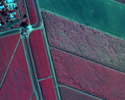
Remote Sensing
Site-wide aerial capture and GIS mapping to plan layout, access and infrastructure before a shovel goes in.
-
Infrastructure mapping
-
Vegetation indexing
Mapping, Consulting & Engineering
From feasibility and environmental assessments to land acquisition and risk mitigation, we provide practical, informed solutions that help projects move forward with confidence, compliance and clarity.
-
Carbon credits
-
Business case formulation
-
Infrastructure design, costing & sourcing
-
Methodology to implementation
-
Geohydrology – Surface & subsurface modelling


Business Information Systems
Our business information systems deliver accurate, real-time reporting and mapping tools that improve oversight, quality control and informed decision-making throughout a project.
-
Ecological Health Monitoring
-
Bare earth analysis
-
Carrying capacity modelling
Previous Projects
 |  |  |  |
|---|---|---|---|
 |  |  |  |
 |  |